Building on Owens Lake dust mitigation design research, a series of design studios 2017-2021 explored the opportunities for revitalizing the Salton Sea playa using parametric patterns and machine choreography to support emergent ecology.
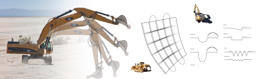


Building on Owens Lake dust mitigation design research, a series of design studios 2017-2021 explored the opportunities for revitalizing the Salton Sea playa using parametric patterns and machine choreography to support emergent ecology.
The final report from my LA6071L + LA6081L Los Angeles River Naturalization Capstone project is available!
Cal Poly Pomona Master of Landscape Architecture students in LA6071L (fall 2022) + LA6081L (spring 2023) Master Project studio, in partnership with LA Waterkeeper evaluated strategies and tactics required to naturalize the Los Angeles River. The team concluded that removing the concrete bottom and restoring native riparian habitat along the entire Los Angeles River is feasible once sufficient storm water retention capacity is developed.
For more about the project, see the river-revitalized page.

Hydrodynamic Modeling of Coastal Flooding
LA402L utilized the USGS Coastal Storm Modeling System (CoSMoS) 3rd generation hydrodynamic models for Southern California to identify areas at risk for inundation and interpolated the timeline in consultation with Dr. Juliette Hart.

Earlier sea level models were static state, so didn’t factor in the significant contribution of waves to coastal flooding, above and beyond the levels observed by the tidal gauges. Interesting to note that the predicted sea levels are higher than the current tsunami risk zone delineation.
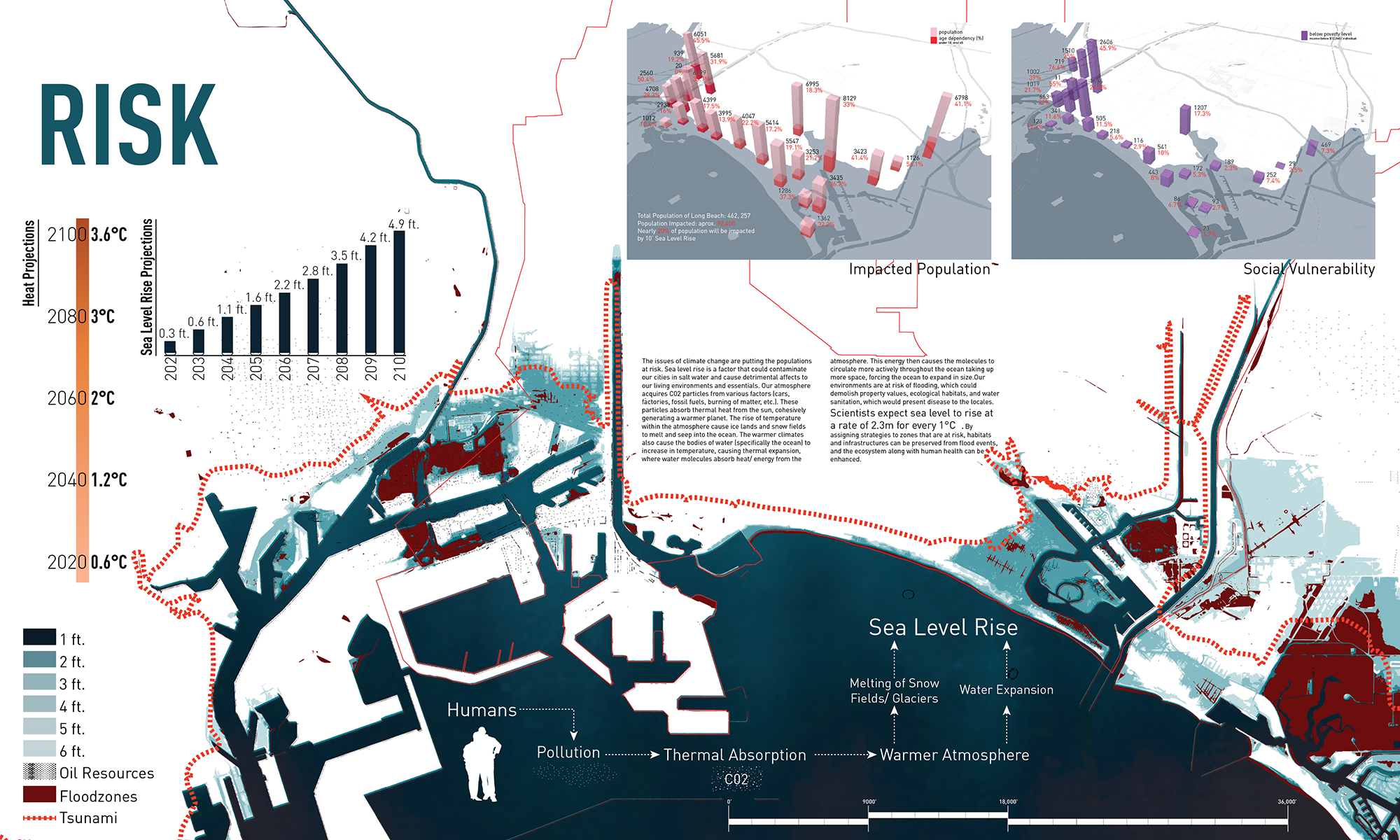
The full LA402L Sea Level Rise Strategies Report: LA402L_LB_SLR_Report-web 51mb.pdf
Excited to share that AHBE Landscape Architects is sponsoring my winter 2017 402L studio! This 4th year BSLA topic studio will develop strategies and tactics for the waterfront of Long Beach and communities along the Lower Los Angeles River to adapt to rising sea levels, urban flooding, and tsunamis. From tactics to schematics, projects will develop site-specific soft infrastructure typologies suitable for wide-scale deployment around Southern California to sustain our ports and vibrant waterfronts.

Screen shot from Climatecentral.org showing the inundation from just a 10 foot rise in sea level.
Our field investigations will take us to Long Beach and out onto San Pedro Bay to explore the interface between water and land (the bravely curious students may need to take Dramamine).
Infrascape readers will be able to follow the students’ progress via their blog posts to http://ahbelab.com.
Stay tuned for updates!
Honored to be able to contribute several illustrations to the 2016 Land Art Generator Initiative book and excited to share them on my blog.


Click for sources Continue reading

Elizabeth Monoian & Robert Ferry, Co-founders of LAGI. Photo by Joanna Totolici, TOTOLICI.COM
Excited to share that artist Elizabeth Monoian & architect Robert Ferry, co-founders of Land Art Generator Initiative (LAGI) are giving a public lecture at 5pm in the atrium of Building 7 on Friday 2/19 at Cal Poly Pomona.
Prior to the lecture, they will be guests in my LA302L & LA402L studios that are designing entries for the 2016 LAGI competition (entry deadline is May 15th), set adjacent to the Santa Monica Pier.

Site visit with LA302L & LA402L
LAGI 2016 is an ideas competition to design a site-specific public artwork that, in addition to its conceptual beauty, has the ability to harness energy cleanly from nature and convert it into electricity and/or drinking water for the City [of Santa Monica]. http://www.landartgenerator.org/competition2016.html
The lecture is being co-sponsored by the Cal Poly Pomona Student Chapter of the American Society of Landscape Architects.

This gallery contains 58 photos.
Toured LAX’s airfield with my LA301L studio on Monday 10/26 to see what we could see. Highlights include the Argo Ditch, sculptures by Ball+Nogales, and several A380 taking off! Argo Ditch (north side of the airfield)
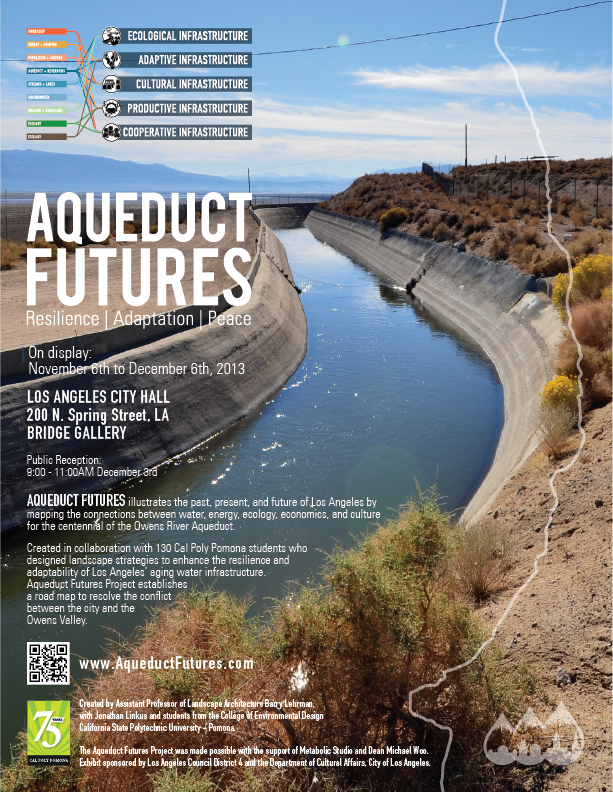
Aqueduct Futures intro Video on Vimeo
Cal Poly Pomona Landscape Architecture students with Prof. Barry Lehrman and Jonathan Linkus (exhibit co-designer) share how the Aqueduct Futures Project has changed their attitudes towards water and came to understand the impact of the Los Angeles Aqueduct to all of California.
This video is under a Creative Commons license: attribute & share alike. All other rights reserved.
Southern California Planning Congress, in cooperation with the California Center for Land and Water Stewardship, Cal Poly Pomona presents
The water history of Los Angeles is marked by natural scarcity, abundance, and drought. This year’s 100th anniversary of the Los Angeles Aqueduct celebrates a reliable and plentiful water source to match an expansionary vision for the city. Yet local water predictability produced resource depletion and legal wrangling in the Owens Valley where the watershed feeds the Aqueduct. Now a project called “Aqueduct Futures” proposes a cooperative 21st century realignment among stakeholders to balance water consumption, watershed ecology, economics, and culture.
Prof. Barry Lehrman, MLA/MArch, ASLA
Project Director, Aqueduct Futures Project,
Department of Landscape Architecture, Cal Poly Pomona
Wednesday, March 19, 2014 (Meet and Greet at 6:30 p.m., Dinner at 7:00 p.m.)
Taix French Restaurant: 1911 West Sunset Boulevard, Los Angeles, CA 90026
$40 general public, $30 Southern California Planning Congress members, $25 students with ID. On-site registration (checks only) is an additional $10 and not guaranteed. On-line registration for this event ends Friday the 14th at 5:00 p.m. Please register, select dinner option, and submit payment at :
www.socalplanningcongress.com
For further information contact Bob Fazio at (626) 765-4036 or at rjfazio@mac.com
This event is eligible for 1.5 hours of AICP Certificate Maintenance Self-Reporting Credit.
The devil is in the details in Los Angeles Department of Power and Water’s 1200 acre Southern Owens Valley Solar Ranch proposal. This post is about a few of the tidbits not included in the DEIR (I, II, & III) or that the consultants have blatantly come to the wrong conclusion about.
Don’t get me wrong, I’m a huge fan of utility scale solar power like this project, BUT only when it is done in the right place and is actually Designed (with a big D) by folks like landscape architectures – not just engineered with no poetry like DWP seems to be doing.


The proximity to Manzanar National Historic Site is the biggest boondoggle and the source of most opposition. There will be SUBSTANTIAL impacts on ‘scenic vistas’ no mater where the project is built (topic AE-1, AE-3 & AE-4). The viewshed analysis from Manzanar and 395 are pretty sloppy – note how the parking lot dominates the foreground. This isn’t the view that most visitors will be offended by.

Plus this part of the Owens Valley has great dark skies with minimal artificial lights near by – the solar ranch will substantially damage one of my favorite star gazing locations even if they try to limit light trespass.

That bright spot is Lone Pine from the Manzanar Airport.

The night sky from the southern alternative site, October 2012
Biggest environmental issue is the impact of pumping an additional 10 acre-feet of groundwater to clean the photovoltaic panels. So how much water will be needed during construction for the concrete foundations and to control dust???
To equal the 200mw capacity of the Solar Ranch, it would take just 20,000 – 40,000 residential installations at 5-10kw each. Since there are 665,992 single family houses in LA per the census, this just means that 17% of houses need to install solar panels to replace the Solar Ranch.
-Or-
The 1200 acres ‘needed’ by DWP can easily be found around Los Angeles on city owned property (for example, the Whitnall Highway R.O.W is about 120 acres)
So the statement that distributed PVs are ‘Infeasible under existing power system operational capabilities without compromising system integrity and safety’ is to kindly state, BS.
Shadows from the Sierra Nevadas and the Inyo Mountains aren’t covered. This diagram was generated by the University of Oregon Solar Path Calculator and Google Earth.

Solar Path and rough estimate of Shadows.

Looking at the insolation aka how cloudy it is, the Owens Valley has pristine blue skies about 25% of the time. Okay, this is using weather data for Bishop which is the nearest NOAA weather station, not for the region near Independence/Manzanar. This is a screen shot of UCLA’s Climate Consultant 5.2, using data from the US Department of Energy.


[Gotta get to bed tonight, I’ll try to update this from the DWP meeting on Saturday or after the fact when I get a chance]
Days from the printer’s deadline for completing the exhibit and everything is coming together with the help of Jonathan Linkus and our great closing team of research assistants (Jane, Ernesto, & Kevin).
One change worth noting is is the public reception has been shifted to Tuesday, December 3rd, 9am-11am!
For this November’s centennial of the LA Aqueduct, two journals (ARID and BOOM) have special issues that are really cool read for infrastructure and landscape folks. Included in ARID are two articles using data collected as part of the Aqueduct Futures project!

Barry J. Lehrman, Douglas Delgado and Mary E. Alm, Ph.D. Aqueduct as Muse: Educating Designers for Multifunctional Landscapes
Lee-Anne Milburn, Ph.D. and Barry Lehrman, with Tiernan Doyle, Eric Haley, James Powell and Devon Santy. Contested Waters, Unholy Alliances, and Globalized Colonies: Exploring the Perception of Water by Residents of the Los Angeles Aqueduct Watershed

On a personal note, ARID Journal also includes my dedication to my late wife, Mary Alm who died after a 15 month fight with cancer in September. I am deeply grateful for the opportunity to write ‘Aqueduct as Muse’ with her.

Mary Alm (1969-2013) was my muse, dear wife of nine years and mother of our son. She died peacefully after a grueling 15-month fight with breast cancer, just days after we submitted the final manuscript to Arid. The week before she was stricken by an undetected metastasis, I was finally able to bring her up to the Owens Valley to see the place that is now the foundation of my academic career.
As the cool and calmly collected presence reigning in my boundless ideas, Mary Alm brought focus to my life and provided the inspiration that encouraged me to aim for the moon.
As a health psychologist, Mary gave me a perspective into human behavior that enriched my scholarship into urban landscape systems and sustainability. This article was our first published collaboration to connect the gulf between our disciplines. Writing together—often at her weekly infusions during the darkness brought by the cancer—gave us strength to persevere against the relentless toll chemotherapy inflicted and to continue to pursue our dreams of future endeavors together.
As a lasting tribute to our love, this article is dedicated to Mary’s genius, goodness, and grace.
–Barry Lehrman, September 5, 2013
There are days that I feel like a rubber band – being stretched in so many different directions. Then I snap back. That is resilience.
Climate resilience is such a seductive concept like regeneration that it is one of the primary topics I teach. But not sure if we actually have the political and economic means to pull it off (nor does Andrew Revkin). Check out the video [which refuses to be embeded] of Revkin’s recent appearance at Zócalo Public Square that focused on the topic.
So what am I doing to shift the status quo? Getting stretched in all sorts of ways organizing a symposium for the LA Aqueduct Centennial with folks from UCLA (including Alex Hall and Jon Christensen who are in the video), Woodbury’s Arid Lands Institute, and my mentor Lance Neckar at Pitzer. Target date winter 2014 if we line up the funding. Stay tuned!
—
A quick shout out to Dan Hill for a fascinating read about the ‘Urban Intelligence Industrial Complex’ aka the ‘Smart City’ movement…
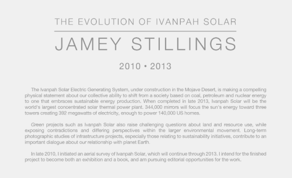
Photographer Jamey Stillings documents the sublime of Ivanpah Solar Electric Generating System for Wired.

Aerial view of Solar Field One at the Ivanpah Solar Electric Generating System (ISEGS) on October 27, 2012. Photo shows completed tower construction and heliostat (pairs of mirrors) installation. Mojave Desert, CA
Some of his photos evoking the Nazca lines or Michael Heizer’s Complex – this is quite the documentation of the infrastructural sublime.

Clark Mountain and ground work for future power block of Solar Field One. January 14, 2011.

View north of Ivanpah Solar showing all three solar fields with heliostat installation complete in Solar Field One in the foreground. October 27, 2012.
There is a remarkable amount of intact vegetation beneath the heliostats – making me wonder if it is possible to design a low-impact solar farm?

Installed heliostats in Solar Field One and adjacent section of undisturbed desert terrain of the site’s alluvial fan. January 6, 2012.

Installed heliostats in “safe” or resting position. June 2, 2012

Workers install a heliostat on a pylon in Solar Field One. June 4, 2012.
More of Jamey Stillings pics at Aerial Photos of Giant Google-Funded Solar Farm Caught in Green Energy Debate | Raw File | Wired.com. and Stillings’ own website.
Cross posted from the aqueductfutures blog
The Bureau of Reclamation is proposing a massive uphill diversion from the Missouri River to Denver. The Missouri River Reuse Project [pdf] would provide 600,000 Acre-Feet of water to the Front Range to as an alternative to desiccating the Upper Colorado even more. This evokes the ghost of the continental engineering of North American Water and Power Alliance (1964) or towing icebergs from Alaska to provide water to Los Angeles.

“The idea of constructing conveyances to move water resources between other basins and the Colorado has been raised before and was once again submitted as an idea in this process,” Bureau of Reclamation public affairs chief Dan DuBray said in a statement. “Any proposal will be evaluated for feasibility, broad support and realistic funding potential before further consideration would be given.” – The Denver Post
