Landscape Futurist 2018

Had the pleasure of being the final speaker in CPPLA’s spring 2018 lecture series with a talk titled “Landscape Futures” that covered my recent scholarship visualizing the interface between infrastructure, ecology, and culture.

You can watch my entire talk on Facebook:

www.facebook.com/calpolypomona.landscapearchitecture/videos/10214762114820499/

This slideshow requires JavaScript.

The rest of my slides are below.

Continue reading

An Aqueduct Runs Through It

Southern California Planning Congress, in cooperation with the California Center for Land and Water Stewardship, Cal Poly Pomona presents

A Series on The Future of California’s Water Supply

Part 1 – Our Water, Our Lifestyle
3/19/2014 @ Taix Restaurant, Echo Park

The Next Hundred Years of the Los Angeles Aqueduct

The water history of Los Angeles is marked by natural scarcity, abundance, and drought. This year’s 100th anniversary of the Los Angeles Aqueduct celebrates a reliable and plentiful water source to match an expansionary vision for the city. Yet local water predictability produced resource depletion and legal wrangling in the Owens Valley where the watershed feeds the Aqueduct. Now a project called “Aqueduct Futures” proposes a cooperative 21st century realignment among stakeholders to balance water consumption, watershed ecology, economics, and culture.

Guest Speaker:

Prof. Barry Lehrman, MLA/MArch, ASLA
Project Director, Aqueduct Futures Project,
Department of Landscape Architecture, Cal Poly Pomona

Event Date and Venue:

Wednesday, March 19, 2014 (Meet and Greet at 6:30 p.m., Dinner at 7:00 p.m.)
Taix French Restaurant: 1911 West Sunset Boulevard, Los Angeles, CA 90026

Registration and Contact:

$40 general public, $30 Southern California Planning Congress members, $25 students with ID. On-site registration (checks only) is an additional $10 and not guaranteed. On-line registration for this event ends Friday the 14th at 5:00 p.m. Please register, select dinner option, and submit payment at :
www.socalplanningcongress.com
For further information contact Bob Fazio at (626) 765-4036 or at rjfazio@mac.com
This event is eligible for 1.5 hours of AICP Certificate Maintenance Self-Reporting Credit.

Solar Ranch pros and cons

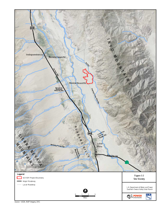
The devil is in the details in Los Angeles Department of Power and Water’s 1200 acre Southern Owens Valley Solar Ranch proposal. This post is about a few of the tidbits not included in the DEIR (I, II, & III) or that the consultants have blatantly come to the wrong conclusion about.

Don’t get me wrong, I’m a huge fan of utility scale solar power like this project, BUT only when it is done in the right place and is actually Designed (with a big D) by folks like landscape architectures – not just engineered with no poetry like DWP seems to be doing.

Page 67 from SOVSR_DEIR_Vol.I_Aug_2013-reduced

Page 89 from SOVSR_DEIR_Vol.I_Aug_2013-reduced-2

Scenic impact

The proximity to Manzanar National Historic Site is the biggest boondoggle and the source of most opposition. There will be SUBSTANTIAL impacts on ‘scenic vistas’ no mater where the project is built (topic AE-1, AE-3 & AE-4). The viewshed analysis from Manzanar and 395 are pretty sloppy – note how the parking lot dominates the foreground. This isn’t the view that most visitors will be offended by.

Page 137 from SOVSR_DEIR_Vol.I_Aug_2013-reduced-3

Plus this part of the Owens Valley has great dark skies with minimal artificial lights near by – the solar ranch will substantially damage one of my favorite star gazing locations even if they try to limit light trespass.

D7K_4069

That bright spot is Lone Pine from the Manzanar Airport.

D7K_4397

The night sky from the southern alternative site, October 2012

Water

Biggest environmental issue is the impact of pumping an additional 10 acre-feet of groundwater to clean the photovoltaic panels. So how much water will be needed during construction for the concrete foundations and to control dust???

Alternative sites

To equal the 200mw capacity of the Solar Ranch, it would take just 20,000 – 40,000 residential installations at 5-10kw each. Since there are 665,992 single family houses in LA per the census, this just means that 17% of houses need to install solar panels to replace the Solar Ranch.
-Or-
The 1200 acres ‘needed’ by DWP can easily be found around Los Angeles on city owned property (for example, the Whitnall Highway R.O.W is about 120 acres)

So the statement that distributed PVs are ‘Infeasible under existing power system operational capabilities without compromising system integrity and safety’ is to kindly state, BS.

Shadows from the Sierra Nevadas and the Inyo Mountains aren’t covered. This diagram was generated by the University of Oregon Solar Path Calculator and Google Earth.

Solar Path and Shadows

Solar Path and rough estimate of Shadows.

Sun Path_Page_1

Looking at the insolation aka how cloudy it is, the Owens Valley has pristine blue skies about 25% of the time. Okay, this is using weather data for Bishop which is the nearest NOAA weather station, not for the region near Independence/Manzanar. This is a screen shot of UCLA’s Climate Consultant 5.2, using data from the US Department of Energy.

Screen Shot 2013-11-14 at 10.48.31 PM

Screen Shot 2013-11-15 at 1.02.28 AM

[Gotta get to bed tonight, I’ll try to update this from the DWP meeting on Saturday or after the fact when I get a chance]

AF Exhibit

Image

Exhibit Flyer

Days from the printer’s deadline for completing the exhibit and everything is coming together with the help of Jonathan Linkus and our great closing team of research assistants (Jane, Ernesto, & Kevin).

One change worth noting is is the public reception has been shifted to Tuesday, December 3rd, 9am-11am!

Looking forward to seeing you there!

ARID Journal & Aqueduct Futures

For this November’s centennial of the LA Aqueduct, two journals (ARID and BOOM) have special issues that are really cool read for infrastructure and landscape folks. Included in ARID are two articles using data collected as part of the Aqueduct Futures project!

Barry J. Lehrman, Douglas Delgado and Mary E. Alm, Ph.D.  Aqueduct as Muse: Educating Designers for Multifunctional Landscapes

Lee-Anne Milburn, Ph.D. and Barry Lehrman, with Tiernan Doyle, Eric Haley, James Powell and Devon Santy.  Contested Waters, Unholy Alliances, and Globalized Colonies: Exploring the Perception of Water by Residents of the Los Angeles Aqueduct Watershed

Grant Lake, (c) Eric Haley 2012

On a personal note, ARID Journal also includes my dedication to my late wife, Mary Alm who died after a 15 month fight with cancer in September. I am deeply grateful for the opportunity to write ‘Aqueduct as Muse’ with her.

Mary Alm, PhD 1969-2013

Mary Alm (1969-2013) was my muse, dear wife of nine years and mother of our son. She died peacefully after a grueling 15-month fight with breast cancer, just days after we submitted the final manuscript to Arid. The week before she was stricken by an undetected metastasis, I was finally able to bring her up to the Owens Valley to see the place that is now the foundation of my academic career.

As the cool and calmly collected presence reigning in my boundless ideas, Mary Alm brought focus to my life and provided the inspiration that encouraged me to aim for the moon.

As a health psychologist, Mary gave me a perspective into human behavior that enriched my scholarship into urban landscape systems and sustainability. This article was our first published collaboration to connect the gulf between our disciplines. Writing together—often at her weekly infusions during the darkness brought by the cancer—gave us strength to persevere against the relentless toll chemotherapy inflicted and to continue to pursue our dreams of future endeavors together.

As a lasting tribute to our love, this article is dedicated to Mary’s genius, goodness, and grace.

–Barry Lehrman, September 5, 2013

Dust Up On Owens Lake Again

The LADWP has pushed back against the shifting target of dust control on Owens Lake, precipitating another round legal battles to ensure the public health along the Eastern Sierras.

So far, the Owens Lake dust control project has reduced emissions of PM10 dust by 90% – this is agreed to by both parties the LADWP and the Great Basin Unified Air Pollution Control District. The conflict is over who should pay for further dust mitigation efforts, most of which is on land that recent archeological research shows was not submerged before the LA Aqueduct was completed in 1913, which defines the area that was agreed to in the 1997 when the dust control project was ratified. So the question is: does the LADWP or the State Land Commission pay for controlling dust on the disputed 10 square miles?

“We have no intention of walking away from our responsibility for the dust at the dry Owens Lake bed,” Nichols said. “But the reality is that we don’t create all the dust out there, never did.”

LADWP’s appeal at the California Air Quality Board is being heard today. So stay tuned for the ruling.

via LATimes

LA Aqueduct Bibliography 2012

I revisited the LA Aqueduct for a grant proposal related to the upcoming centennial of it’s opening (stay tuned), and started updating my earlier bibliography. My methodology was searching via google scholar, amazon.com and cal poly’s library. Items in bold are seminal books and essential reading about the LA Aqueduct. The links take you to the most recent edition of the book.

(all images by HAER/Library of Congress.)

OWENS RIVER DIVERSION GATES

2012

2011

2010

2009

2008

Alabama Gates

Continue reading

Complete report on construction of the Los Angeles Aqueduct (1916)

While researching my 4th year studio for winter quarter 2012, I discovered that the source of some of my favorite drawings of the Los Angeles Aqueduct is now a Google Books: http://books.google.com/books?id=7yIWAAAAYAAJ

Commissioners, Los Angeles (Calif.). Board of Public Service. 1916. Complete report on construction of the Los Angeles aqueduct; with introductory historical sketch; illustrated with maps, drawings and photographs. Los Angeles Department of Public Service.

LORP revisited

the LAtimes revisits the Lower Owens River Restoration Project:

Mark Hill, the lead scientist in the Lower Owens River Project, pointed out that “if you’re a fish or a duck, the project has been a boffo box office success. We’ve created 3,000 acres of water and wetlands. There are 4,000 largemouth bass and 2,000 bluegill per mile, and 108 species of birds, 41 of them new to the area.

“The only issue plaguing us right now is too many tules and, as a result, there are huge access problems when it comes to angling and boating,” Hill said. “But we have a plan to deal with them.”

I take major issue with the LATimes characterization of the restoration project as a failure, where they portray the verdant tules is a negative feature because of how it  limits human access to the river.

Check out the 2007 video of the river 6 months after the flow was restored.

my friend and Owen Lake hero Mike Prather.

Creating Lower Owens River Master Plan seems like a great studio project!

solar design – moving beyond the farm

As a landscape architect, I cringe when I see massive engineering and infrastructure projects that demonstrate no sensitivity to the site, ecology, or culture. Solar power and renewable energy projects are no exception. There needs to be a better way to deploy large scale solar energy projects that reduce their cultural and ecological impact on the landscape.

There is an interesting etymology emerging for solar power projects that have agricultural and ecological imagery. Solar farms, solar groves, solar forest, solar trees, solar ranch, and bright fields, all evoke sylvan or pastoral landscapes while the reality is anything but that in most cases. If we play this game – solar orchards, solar gardens, solar bosques, solar glens, solar dell, solar pastures, solar glades, solar forest, solar plantation, solar jungles, solar meadows, solar pastures, solar shrubs, solar trees, and perhaps solar topiaries – may all soon to join the lexicon of solar projects for better or worse.

Compared to most other forms of energy, solar farms have one of the lightest impact no mater how you slice it – EROEI, LCA, area per watt, co2e/watt or btu, et cetera. Robert Bryce got the math wrong by ignoring the baseline of fossil fuel impacts in his June NYTimes Op-Ed. Yes – solar and wind farms require large areas (if not build in urban areas), but their footprints are minimal compared to fossil fuels which require equally large areas that are usually hidden from public view – from the mines/oil fields, to processing plants/refineries, pipelines, tank farms, and then there is the area contaminated downwind and down stream that Bryce is paid to ignore. Okay, there are toxic byproducts of both thin film and silicon cell production, but again, these are significantly lower per watt then most other forms of energy production.

Yes, solar energy development may require removal of vegetation over tens of square miles (which impacts the ability to keep the mirrors clean), digging the point foundations for the heliostats (see image below) & turbines, and depletion of groundwater to keep the panels/mirrors clean. But compared to the other renewable energy systems, solar’s environmental impacts are an order of magnitude less then wind farms which sprawl over much more land, mix the atmosphere, require massive foundations and structures, and create noise problems to name just a few issues; or are several orders of magnitudes less then hydropower and most biofuels. Energy sprawl is real, but don’t blame wind or solar.

Still, this small footprint  isn’t good enough, but now there is hope for integrating photovoltaics into our cultural landscape.

Continue reading

Karen Piper on Owens Lake

Over on Places, there is a thoughtful essay on Owens Lake by english professor and Ridgecrest native,  Karen Piper, titled ‘Dreams, Dust and Birds: The Trashing of Owens Lake’ about the unfeasible proposed solar farm.

Preliminary engineering tests show that if solar panel platforms were placed at the southern end of the nearly dry 110-square-mile Owens Lake, they would sink as much as several inches into extremely corrosive soil.” [LATimes]

Beyond offering some fresh views on the infrastructural void left by the Los Angeles Aquaduct, the editors at Places asked to use one of my photos (above)!

The post also contains one of the first pics of ‘moat and row’ in the bottom left below:

Top: Owens Lake and the Sierra Nevada. [by Satoshi Nakagawa] Bottom left: Moat and Row dust control at Owens Lake. [by Karen Piper] Bottom right: The Karen Piper’s white Kia. [by Karen Piper]

OWENS LAKE Symbiosis: infrastructural ruralism

To wrap up the collective reading of my chapter, ‘Reconstructing the Void: Owens Lake’ from The Infrastructural City organized by Mammoth, here is my 2005 MLA/MArch University of Pennsylvania thesis project. #mammothbook

Thesis

What is infrastructure’s cultural role in the rural landscape?

  • How to adapt static large-scale civil projects into dynamic emergent systems?
  • How to adapt single use infrastructure to multiple uses?
  • How to transform infrastructure into an evident contributor of place?

Definitions

RURAL: places that human activities are sufficiently present to be obvious, but with a low population; contrasted to wilderness where the traces are few and far between. [http://roadless.fs.fed.us]

SYMBIOSIS: Two or more dissimilar organisms living together in close association with one another.

PARASITISM, where one of the organisms harms the other(s),

MUTUALISM, where association is advantageous to all

and
COMMENSALISM,
where association is advantageous to one organism but doesn’t affect other organism(s). [www.ucbiotech.org/glossary]

Project goals:

Design a water containment system (levees, dams, channels, and earthworks) to create a low-salinity/deeper pool in the lakebed, fed by the Owens River & mitigation.

Nearby, design structures & access network for the inhabitation and the intimate experience of the lake (observation, sleeping, eating, et cetera) that engage the landscape and visitors.

PROGRAMATIC USE:

Ephemeral habitation of the Owens Lakeshore and the Los Angeles Aqueduct.

Users:

Foreign Tourists
Fishermen
Hikers/Naturalists
Hang Gliders/Sail Planers
Cultural Heritage Tourists
Birdwatchers
Travelers

Only the Snowy Plover is accommodated within the current mitigation process. No other animal/plant has been considered.

How to make this place useable by people and other critters?

Summary

Develop an Infrastructure that has a cultural role & multiple uses
Mitigate the impact of the Los Angeles Aqueduct:

  • Reclaim Owens Lake through partitioning the basin into a brackish lake and a hypersaline lake
  • Tie Owens Lake and the Los Angeles Aqueduct together with a system for ephemeral habitation and occupation

______

Here is the November draft of my thesis proposal that was approved by my Committee.

The final presentation...

Design

Continue reading

Owens Lake & LA Aqueduct Bibliography

To enhance the collective reading of The Infrastructural City organized by Mammoth, here are the highlights of the bibliographic sources from my research into Owens Lake for ‘Reconstructing the Void: Owens Lake’ and my thesis project (circa 2005). Drop me a note if you need help locating any of these sources or find new items that need to be added. #mammothbook

Owens Valley

Bishop Visitors Center; Welcome to Bishop 2003 Press Kit. Bishop California

Center for Land Use Interpretation, ‘California’s Owens Valley’, The Lay of the Land, Summer 2004

Department of Defense; Checklist of Birds, Edwards Air Force Base, California. Department of Defense. Jamestown, ND: Northern Prairie Wildlife Research Center Online. (Version 23JUN00)

Ewan, Rebecca Fish; A Land Between – Owens Valley, California. Baltimore, John Hopkins University Press, 2000.

Hall, Clarence A., et al- editors; The History of Water: Eastern Sierra Nevada, Owens Valley, White-Inyo Mountains. White Mountain Research Station Symposium, Volume 4. Los Angeles: University of California, 1992.

Hoffman, Abraham; Vision Or Villainy: Origins Of The Owens Valley-Los Angeles Water Controversy. College Station: Texas A&M University Press, 1981.

James, Greg, Dennis Williams, et al; Green Book for the Long-term Management Plan for the Owens Valley and Inyo County. Bishop, CA: June 1990.

Gary LibecapChinatown: Transaction Costs in Water Rights Exchanges The Owens Valley Transfer to Los Angeles’, (NSF Grant 0317375). [This paper explodes the myth that Los Angeles ‘stole’ the water from the Owens Valley, and why the farmers were eager to sell.

Olson, Wilma R; Olancha Remembered. Sacramento, CA: W.R. Olson 1997

Putnam, J. & G. Smith, editors; Deepest Valley: A Guide to Owens Valley, Its Roadside and Mountain Trails– 2nd Edition. Palo Alto: Genny Smith Books/Live Oak Press, 1995.

Sharp, Robert & Allen Glazner; Geology Underfoot in Death Valley and Owens Valley. Missoula Montana: Mountain Press Publishing 1997.
Timmer, Kerri L.; Troubled Water of the Sierra, Sierra Nevada Alliance

Varnelis, Kazys; Points of Interest in the Owens River Valley. Culver City, CA: Center for Land Use Interpretation, 2004.

Wood, R. Coke; The Owens Valley and the Los Angeles Water Controversy – Owens Valley as I Knew It. Stockton CA: University of the Pacific, 1973.

Continue reading

Writing ‘Infrastructure of the Void’

As part of my engagement with the collective reading of The Infrastructural City organized by Mammoth, I wanted to share the process and backstory about my chapter in the book – ‘Reconstructing the Void: Owens Lake’. #mammothbook

The chapter title

‘Until Los Angeles’ was my working title of the drafts from October 2006 to May 2007 . ‘Infrastructure of the Void’ was the second working title and the one I’m still the most fond of. ‘Reconstructing the Void: Owens Lake’ was coined by Kazys Varnelis in the 20070820 Owens Draft. But the chapter has a longer history worth sharing.

The Back Story

The chapter emerged from the research component from my MLA/MArch thesis, the design of an alternate dust mitigation system to restore Owens Lake and create a hybrid landscape for tourism and habitat. As a resident of LA for several years before grad school, I first visited the Owens Valley on a spur of the moment road trip on Memorial Day weekend in 1998. I looked at a map of California and pointed my car into the unknown of the Eastern slopes of the Sierra Nevadas and have been haunted by Owens Valley ever since.

Then in summer of 2004, with the intent and dream of return to California, I initially choose the Los Angeles Aqueduct as my thesis topic. Through the arduous thesis proposal/approval process, the Owens Lake Playa became my focus and site.

From the Complete Report on Construction of the Los Angeles Aqueduct, 1916.

Continue reading

reading ‘the infrastructural city’ proposal

Dust control 'bubblers' on Owens Lake

Mammoth is organizing a webwide book club blogging even focused on on The Infrastructural City starting at the end of April. I will certainly join in fun for my chapter on Owens Lake. Maybe even post some of the drafts and parts that didn’t make the cut into the book.

For each of the twelve chapters, mammoth will post a piece summarizing and commenting on that chapter as a conversation starter, but we hope that a rich discussion will spiral out from that central hub, through comments, through other participating blogs (currently including dpr-barcelona, faslanyc, free association design, Nam Henderson, Andrew and Peter of the polis blog, and quiet babylon we’ll provide links to posts at other blogs discussing each chapter as they’re posted), and into other corners of the internet (twitter, etc.). To that end, participation in this discussion — this “book club” — is open to any and all interested readers. In order to join us, all you need is a copy of The Infrastructural City, a bit of time to read along, and an interest in discussing landscape, architecture, and infrastructure.

If you’re using twitter, you can follow the conversation, announcements, and so on using the hashtag #mammothbook; you may also care to join or follow the “twub” which the folks at dpr-barcelona have been kind enough to set up for the group, and which will serve as an archive for all #mammothbook tweets.

We won’t start discussing the first chapter, “Owens Lake”, until Monday, April 26th, in order to give all interested persons an opportunity to pick up the book and start reading (and writing, if you’re so inclined) before the discussion gets started. After that, we’ll be discussing one chapter a week, taking a break on every fourth week. In the meantime, we’d love to hear from everyone who is interested in participating, in the comments of this post. If you’d like to participate, be sure to leave your email address — we’ll be sending out reminder emails a little bit in advance of each week’s discussion.

Schedule
April 26th Owens Lake <—– this is my chapter!

May 3rd Los Angeles River Watershed + The River (images)
May 10th Oil
May 17th (off)
May 24th Gravel
May 31st Traffic + The Street (images)

June 7th Telecommunications
June 14th (off)
June 21st Landscape
June 28th Mobile Phones

July 5th Property
July 12th (off)
July 19th Distribution + The Trench (images)

August 2nd Props
August 9th Introduction

…[R]ead reviews of The Infrastructural City at Places Journal, Archidose, and We Make Money Not Art.