Building on Owens Lake dust mitigation design research, a series of design studios 2017-2021 explored the opportunities for revitalizing the Salton Sea playa using parametric patterns and machine choreography to support emergent ecology.
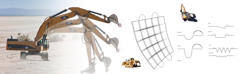


Building on Owens Lake dust mitigation design research, a series of design studios 2017-2021 explored the opportunities for revitalizing the Salton Sea playa using parametric patterns and machine choreography to support emergent ecology.
The final report from my LA6071L + LA6081L Los Angeles River Naturalization Capstone project is available!
Cal Poly Pomona Master of Landscape Architecture students in LA6071L (fall 2022) + LA6081L (spring 2023) Master Project studio, in partnership with LA Waterkeeper evaluated strategies and tactics required to naturalize the Los Angeles River. The team concluded that removing the concrete bottom and restoring native riparian habitat along the entire Los Angeles River is feasible once sufficient storm water retention capacity is developed.
For more about the project, see the river-revitalized page.

6/15/2021 My latest funded grant is $24,950 for Google Street View Tools (and more) for Remote and In-Person Instruction. This Cal Poly Pomona Special Projects to Improve Classroom Experience (SPICE) Grant funded by Student Success Fees.

Inspiration for the proposal was the virtual field trip I planned for LA3121L spring ’21 Salton Sea studio and getting to borrow MediaVision’s Insta360 Pro2 8k panoramic video camera to document the project site for Google Street View. Over two road-trips in January, I recording dozens of miles of Imperial County roads and hiking along shoreline with the camera jury-rigged to car and mounted on backpack.
The grant will enable getting a dedicated camera, proper mounts to allow students to use the camera, precision RTK GPS IMUs, a powerful Dell Precision 5280 workstation, and storage cabinets.
Grant Application File
‘(and More)’ in the grant title is establishing the ENV Advanced Design Computing Lab in collaboration with Prof. Weimin Li who also got a SPICE grant to purchase a multi-touch tabletop computer for interactive geodesign instruction. While the final location of the lab is TBD, we will be getting two storage cabinets to house our collection of drones, environmental sensors, the 360 panoramic camera and camera mounts, and other items crowding our faculty offices for students/colleagues to access.
 On 8/28/2018, had the pleasure of being interviewed by A Martinez for KPCC’s Take Two about how Southern California can adapt to sea level rise and the expected impacts.
Listen here.
 My article, Visualizing Water Infrastructure with Sankey Maps: a Case Study of Mapping the Los Angeles Aqueduct, California, was just published in Journal of Maps!!! In it, I dive deep into the theory and practices behind the signature Sankey map of the Aqueduct Futures exhibit with a peer reviewed research article. You can read the full article (it’s open-access thanks to the College of Environmental Design) at DOI: 10.1080/17445647.2018.1473815.

ABSTRACT:
Creating resilience for urban water supply systems requires innovative thematic visualizations of the interface between infrastructure, ecology, and culture to viscerally engage lay audiences in the policy making process. Sankey maps (a hybrid Sankey diagram/flow map) embed the systemic accounting of flows between sources and sinks into a spatial framework. This allows a hierarchy of visual variables to encode environmental conditions and historical data, providing a rich multi-variate context supporting public discourse, policy making, and system operations. The article features a Sankey map of the Los Angeles Aqueduct system (California, USA) (not to scale).
If you want to learn more about flow maps after reading my article, check out my post sharing many of the precedents mentioned.
Had the pleasure of being the final speaker in CPPLA’s spring 2018 lecture series with a talk titled “Landscape Futures” that covered my recent scholarship visualizing the interface between infrastructure, ecology, and culture.
You can watch my entire talk on Facebook:
www.facebook.com/calpolypomona.landscapearchitecture/videos/10214762114820499/
The rest of my slides are below.
Since 2013, I’ve acquired and deployed a range of environmental sensors. My initial plans for the data were to define baseline environmental (which ended up being beyond my means). Finally figured out how to merge my inner Maker with my infrastructural fascination by using environmental data streams in interactive design elements that poetically reveal hidden flows and changes or creates immersive experiences.
This concept – researching how revealing environmental conditions and technological flows along infrastructural pipes and wire in situ can generate awareness to inspire behavior change with public, combines several of my research interests and is the focus of my fall 2017 sabbatical project .
So what sensors and data loggers do I have?
First online in 2013, my Onset HOBO U30 data logger is configured to collect ETo data (1@air temp/humidity, 2@ ground temp, 2@soil moisture, 1@net radiation, 1@wind speed, just missing a rain gauge) on my patio. This entry-level research-grade suite of sensors and the data logger cost about $3,000, and serves as my reference to calibrate the other sensors as needed. The U30 has the ability to control two relays and to send an alarm signal that can trigger other microcontrollers. But Onset has created a proprietary ecosystem with limited customization possible (and haven’t found anybody trying to hack them yet).

About the size of a deck of cards, the Stalker v2.3, an ATmega328P Arduino compatible wireless sensor node packaged with a 0.5 watt PV panel and LiPo battery, supporting a range of sensors and networking options. This was the microcontroller used by the students in my LA301L studio in 2014, so I now have 5 of them, a ZigBee (XBee) wireless mesh networking shield (a low energy version of wifi, that I haven’t gotten to work), a Bee GPS card, two Grove Dust Sensors, a 8×8 LED matrix, a 10 LED bar, and several other sensors.

Image from SeeedStudio
I got on board the kickstart campaign for a Smart Citizen Kit and ran into some difficulties deploying it. Instead of real-time streaming data via wifi to www.smartcitizen.me, it has been sitting in a box since I ripped the USB jack off the board (the 3D printed enclosure is too small!). This was after I used the wrong settings while configuring it and lost the ability to communicate to it via USB, which Acrobotic kindly fixed by reburning the bootloader.

For 2017’s sabbatical project, I’m getting a $30 Teensy 3.6, an Arduino compatible development board featuring a much faster processor (32-bit 180 MHz ARM Cortex-M4 processor) and loaded with 256kb RAM plus all sorts of goodies (specs). It is powerful enough to drive thousands of LED pixels (or hundreds of animation frames), yet only 2.5 inches long!
Check out: https://youtu.be/a1UGDOdKcVg
I’ve also been eying getting 2 or more Feather M0 with RFM95 LoRa Radio – 900MHz if I need wireless networking abilities – as the LoRA protocol is supposed to be simpler to implement then ZigBee and they have a much longer range.
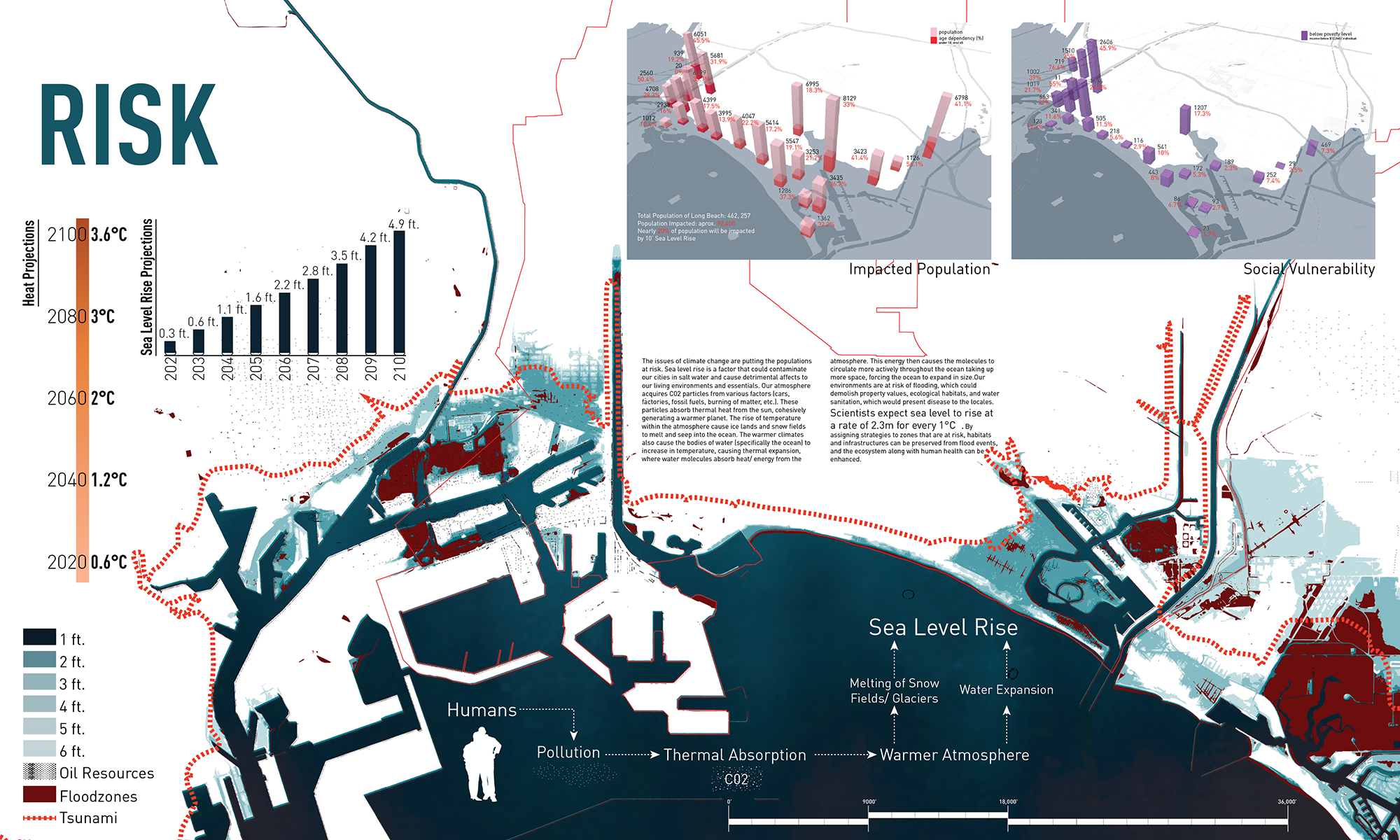
Hydrodynamic Modeling of Coastal Flooding
LA402L utilized the USGS Coastal Storm Modeling System (CoSMoS) 3rd generation hydrodynamic models for Southern California to identify areas at risk for inundation and interpolated the timeline in consultation with Dr. Juliette Hart.
Earlier sea level models were static state, so didn’t factor in the significant contribution of waves to coastal flooding, above and beyond the levels observed by the tidal gauges. Interesting to note that the predicted sea levels are higher than the current tsunami risk zone delineation.
The full LA402L Sea Level Rise Strategies Report: LA402L_LB_SLR_Report-web 51mb.pdf
Over ten weeks in the winter of 2017, sixteen BSLA students my LA402L Advanced Landscape Architecture Studio at California State Polytechnic University, in collaboration with AHBE Landscape Architects (Los Angeles), developed site-specific strategies and tactics to assist the City of Long Beach’s efforts to plan for sea level rise (SLR).

Sea Level Rise strategies and tactics identified by the students of LA402L provide a range of short term mitigation tactics of the impacts and/or long-term adaptation opportunities for the community and waterfront. These strategies and tactics can be categorized as:
Centralized: defined by top-down policies or regulations, neighborhood or community-wide deployment, and reliance on public funding to implement.
Decentralized: implementable by individual property owners and occupants to protect a single building, parcel, or block. These strategies and tactics may require changes to the zoning or building code, and/or innovative construction approaches.
Together with the mitigation and adaptation strategies and tactics (below), the matrix of Decentralized/Centralized and Mitigation/Adaptation is abbreviated as “DCxMA”. Continue reading
Excited to share that AHBE Landscape Architects is sponsoring my winter 2017 402L studio! This 4th year BSLA topic studio will develop strategies and tactics for the waterfront of Long Beach and communities along the Lower Los Angeles River to adapt to rising sea levels, urban flooding, and tsunamis. From tactics to schematics, projects will develop site-specific soft infrastructure typologies suitable for wide-scale deployment around Southern California to sustain our ports and vibrant waterfronts.

Screen shot from Climatecentral.org showing the inundation from just a 10 foot rise in sea level.
Our field investigations will take us to Long Beach and out onto San Pedro Bay to explore the interface between water and land (the bravely curious students may need to take Dramamine).
Infrascape readers will be able to follow the students’ progress via their blog posts to http://ahbelab.com.
Stay tuned for updates!
Honored to be able to contribute several illustrations to the 2016 Land Art Generator Initiative book and excited to share them on my blog.


Click for sources Continue reading

Elizabeth Monoian & Robert Ferry, Co-founders of LAGI. Photo by Joanna Totolici, TOTOLICI.COM
Excited to share that artist Elizabeth Monoian & architect Robert Ferry, co-founders of Land Art Generator Initiative (LAGI) are giving a public lecture at 5pm in the atrium of Building 7 on Friday 2/19 at Cal Poly Pomona.
Prior to the lecture, they will be guests in my LA302L & LA402L studios that are designing entries for the 2016 LAGI competition (entry deadline is May 15th), set adjacent to the Santa Monica Pier.

Site visit with LA302L & LA402L
LAGI 2016 is an ideas competition to design a site-specific public artwork that, in addition to its conceptual beauty, has the ability to harness energy cleanly from nature and convert it into electricity and/or drinking water for the City [of Santa Monica]. http://www.landartgenerator.org/competition2016.html
The lecture is being co-sponsored by the Cal Poly Pomona Student Chapter of the American Society of Landscape Architects.

This gallery contains 58 photos.
Toured LAX’s airfield with my LA301L studio on Monday 10/26 to see what we could see. Highlights include the Argo Ditch, sculptures by Ball+Nogales, and several A380 taking off! Argo Ditch (north side of the airfield)

Source: Wikipedia
As the gateway to the metropolis, LAX is a 3,425-acre void in the urban fabric. This studio will explore opportunities to address contemporary urban and ecological issues in the vast interstitial zones between the aviation and logistics hardscapes.
Projects in this 301L.02 will explore mapping landscape systems, visual variables and pattern generation, and use/event theory to support the final project.
Upon successful completion of this studio, students will gain the following design frameworks and methods:
My entry for the Dry Futures Competition in the Pragmatic category.

Recharge City evaluates pragmatic options for recharging the groundwater in Los Angeles County by recycling the 502 million gallons of water that is dumped by Hyperion Treatment Plant and the Joint Water Pollution Control Plant into the Pacific each day. This is enough water to quench the thirst of 5 1/2 million people.
To identify plausible sites for recharge, this project undertook a holistic mapping of the water infrastructure for the metropolis – ultimately collecting data from over 50 local, state, and federal agencies.
Recycling water is a necessity for Southern California to survive, so how can this massive infrastructure project to close the water loop create a better city for us to live in?
RechargeCity_entry [22mb rasterized pdf]
Recharge City Submission_flat-optimized [35mb pdf]
